 On November 9, 2014, Epson will participate in a disaster response exercise using Universal Transverse Mercator (UTM) maps in Tagajo City, Miyagi Prefecture in Japan. The exercise will be conducted as part of Michinoku Alert 2014, a wide-scale disaster response exercise that simulates a severe earthquake in Tohoku (the northeastern region of Japan that was formerly called "Michinoku"). The project will be a collaborative effort with Tagajo, the Northeastern Army of the Ground Self-Defense Force (GSDF), and Tohoku University.
Universal Transverse Mercator maps* are grid-based maps that divide up the Earth using parallel vertical and horizontal lines, providing a simple and accurate method for identifying locations from a set of coordinates. The UTM system uses location coordinates that are normally only six to eight digits in length, making them shorter than latitude and longitude coordinates.
In severe natural disasters such as the devastating earthquake and tsunami that struck eastern Japan in 2011, signs, buildings, and other landmarks were eradicated, making it difficult for rescue workers on the ground to provide accurate position information to the disaster task force, thus hindering rescue efforts. In one of the exercises in Michinoku Alert 2014, the Tagajo City disaster team and members of the GSDF will use UTM grid coordinates to regularly notify the disaster task force of their position and the state of damage on the ground. The purpose is to validate the effectiveness of the UTM grid system during a disaster response.
As described below, each of the four parties involved in the exercise will play a different role.
Epson
Epson will serve primarily in a support capacity, providing Epson products (see below) that help enable damage assessment, rapid movement of rescue teams, relief supply transport, and personal evacuation and rescue.
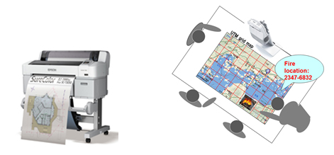
Specially adapted Runsense GPS monitors that display UTM grid coordinates Members of the Tagajo City disaster team and GSDF will wear Epson's Runsense GPS monitors to periodically notify the disaster task force of their UTM grid position and conditions on the ground. After the exercise is completed, its effectiveness will be examined by analyzing the Runsense GPS data logs, which show data such as the wearers' movements.
Large-format printers, short-throw tabletop projectors
The large-format printers and projectors will allow the disaster task force to print out and project UTM maps that show the extent of damage at different locations based on UTM grid coordinates and descriptions from the field.
Color label printer
This printer will print UTM grid location information on stickers. The stickers will be posted in key locations around the disaster exercise area to support reporting of UTM grid location from the field.
Business inkjet printers for email printing (with cloud service)
Information gathered by the disaster task force will be sent over the cloud to be printed by business inkjet printers with their own email addresses, so that paper documents can be rapidly provided to evacuation centers and disaster response team members.
Tagajo City
Members of the city government will conduct a variety of exercises with local citizens and organizations that respond to major disasters. They will work in line with a community disaster plan that is based on lessons learned from the 2011 earthquake and tsunami. They will test the effectiveness of standard UTM maps in the response effort, including the exchange of information in the immediate aftermath of a disaster and the usefulness of that information in effecting rapid rescue efforts.
North Eastern Army of the Ground Self-Defense Force
The GSDF and local government will use the same UTM maps as the city to enable a swift, effective, and coordinated emergency response. Members of the GSDF will use GPS devices to verify whether damage assessments and reports are accurate and efficient.
Tohoku University - International Research Institute of Disaster Science
Tohoku University will scientifically verify the effect that transmission of position data using the UTM grid during the disaster response brings to the accuracy and efficiency of position identification.
As a common language for identifying location that can be used by police agencies, fire agencies, municipal governments, the Self-Defense Force, and various public groups, the UTM grid holds promise for use during disaster and alpine accident rescue efforts. For this reason, Japan is encouraging the use of UTM maps, and the Geographical Survey Institute has been providing printable UTM maps on its website since 2013. Using what it learns from the upcoming exercise, Epson will look to integrate its products and services with the UTM grid to create an environment that allows the UTM grid to be used more easily.
About Michinoku Alert 2014
The North Eastern Army of the Ground Self-Defense Force will conduct this large-scale disaster response exercise for four days, from November 6 through 9. The exercise, which will span the six prefectures in the Tohoku region, will simulate a scenario in which a severe earthquake rocks the region. Based on lessons learned when it was sent on a disaster relief mission in the aftermath of the 2011 earthquake and tsunami, the GSDF will check coordination with local government and other agencies and organizations in an effort to improve the ability to cope with major disasters. Michinoku Alert was first conducted in 2008. Michinoku Alert 2014 marks the second time that this event will be held. This year the exercise will be conducted based on the scenario that a magnitude-9.0 earthquake has hit off the coast of Miyagi prefecture and produced a huge tsunami. U.S. and Australian forces will participate in Michinoku Alert 2014 along with Japan's Air, Sea, and Ground Self-Defense Forces, local governments, and other agencies and organizations.
* Universal Transverse Mercator mapping
An international standard type of map projection. Many countries use UTM mapping as the primary means for projecting medium scale maps. In Japan the UTM system is used for 1:10,000 to 1:200,000 scale topographic maps issued by the Geographical Survey Institute.
www.epson.com